
By Eric Fowler
I’ve paddled many of the state’s rivers, mostly during the past 20 years creating stories on the state’s water trails in this magazine. But until 2018, I hadn’t floated the Platte, despite living a mere 30 miles from its course. By then, my wife, Theresa, and I had owned kayaks for five years, but we mostly paddled lakes around our home in Lincoln.
On this day, it wasn’t long before we asked ourselves why we’d waited so long to float the Platte.
The Nebraska Game and Parks Commission has long promoted a 70-mile water trail on the Platte between Fremont and Plattsmouth. Under the Commission’s Venture Parks initiative, new access points were developed on the Lower Platte at Schramm Park and Louisville state recreation areas, and a stop midway at Platte River State Park, making a 6-mile section of the trail, located within an hour of more than half of the state’s 1.9 million residents, more user friendly.
The Platte River begins nearly 900 miles west of this section of the water trail, on 12,000-foot-high peaks high in the Rocky Mountains of Colorado. Its north fork, the North Platte, flows into Wyoming and turns east, entering the Nebraska Panhandle near Henry. The South Platte flows northeast through Colorado and into Nebraska near Big Springs. The two forks join at North Platte to form the Platte, which ends just 16 miles below the trail where it meets the Missouri River.
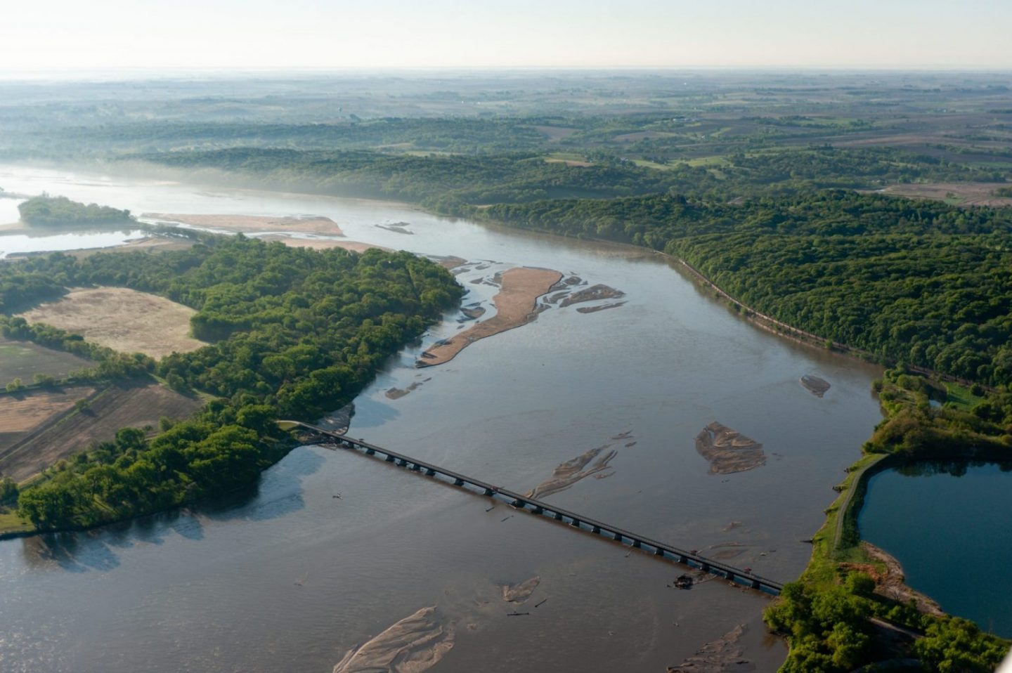
Through most of Nebraska, the river flows through a valley so broad it might be imperceptible to some. By the time it reaches Schramm Park, its valley is narrow, bordered by picturesque wooded bluffs that rise from one bank or the other, providing a scenic backdrop that adds to the experience on this water trail.
The Platte is a braided river, with many small channels winding between its high banks, constantly shifting the sand and gravel that make up its bed and forming expansive sandbars. It typically flows at between 2 and 3 miles per hour in this reach, so paddling only enough to keep on course you could expect the trip from Schramm to Louisville to take three hours or less.
The redesigned section of the Platte River Water Trail begins on the southeastern corner of Schramm, where a new parking lot and launch were developed on the south side of Highway 31 and opened in 2016. Flooding in March 2019 damaged the launch, and the river drops off fairly quickly from the bank, but it is usable. Game and Parks staff is looking at ways to improve the site.
The river flows southeast from Schramm. About 1.5 miles below the park, it passes beneath the Lied Bridge, a former Rock Island Railroad line that is now part of a hike-bike trail that will eventually link trails in Lincoln and Omaha. Paddlers need to choose their route carefully under this bridge as its pilings often collect trees and other debris that should be avoided.
About one-half mile below the bridge, the river turns to the northeast. Another mile downstream, paddlers can turn up Decker Creek, pass under the Burlington Northern Railroad bridge, and take a break at the new stop at Platte River State Park. The bank of the creek has been graded and surfaced with gravel, and a sidewalk leads to a picnic area for paddlers and others to use. Because of the distance from the nearest park road, the site wasn’t built to be a put-in or take-out point. But anyone wanting to wheel their canoe or kayak down a maintenance road can do so.
From Platte River State Park, the river continues to the northeast. In just under 1½ miles, paddlers will reach the western edge of Louisville SRA. Here, they might opt to pitch a tent and spend the night in the River View Campground, which is accessible from the river, albeit by a steep bank. The end of the Platte River water trail is another mile downstream at the east end of the park. This new canoe and kayak access point, boat ramp and parking area opened this spring, a year later than planned thanks to damage caused by flooding last March that has since been repaired.
Shuttling vehicles between Schramm and Louisville is a quick, 7-mile trip along Highways 31 and 50. The Platte River Water Trail had continued beyond Louisville to Schilling Wildlife Management Area at Plattsmouth, but flooding in 2019 washed out the access point and roads leading to it. Another option for an extended day trip exists, however. Paddlers can launch at Catfish Run WMA on Highway 6 east of Ashland and float 2 miles down Salt Creek to its mouth at the Platte, which is 3.8 miles above the launch at Schramm. Other upstream access points include Two Rivers SRA near Venice and Platte River Landing near Valley.
Paddling the river can be a challenge, however, if you don’t know how to read a river and stay in the main channel, especially when flows are low. Choose the wrong course and your float trip will become much longer as you drag your boat back to deep water.
On this reach, however, staying in deep water isn’t difficult. While the main channel can shift at any time, it typically follows the left bank south from Schramm, moves to the center of the river above the Lied Bridge, and, after the river turns to the northeast, follows the right bank to Platte River State Park. From there to Louisville, the channel may cross to the north bank and back a time or two, but it is typically deep enough to float along the south bank.
The amount of water in the river varies widely throughout the year, a factor that can also affect float times. Numerous dams have changed the historic flows in the river. Today, it is typically highest in May and June, but runoff from heavy rains can push flows to dangerous levels during any month. From July until the irrigation season ends in September, flows are lower when the diversion of surface water and groundwater pumping, for agriculture and municipal use, is at its peak. In dry years, the river may be too low to float (see page 26).
But on a summer day, a trip down this section of the Platte River is well worth the effort. And when conditions are right, there is little effort required at all, leaving plenty of time to soak in the scenery and some sun.
When to Float
Water levels in the Platte River vary widely throughout the year and can often be too high to float safely or too low to make the trip enjoyable.
Greg Wagner, a Game and Parks public information officer in Omaha, says as a general rule, if you don’t see any sandbars, the river is too high to float, and if you see more sandbars than water, your trip might be more walking than paddling.
Joel Jorgensen, a Game and Parks biologist who has spent many summers surveying least tern and piping plover nests on the river, has another tool that is useful for those who don’t live near the river and want to check flows before they make the drive. He watches the U.S. Geological Survey stream gauge on the Platte at Louisville closely when determining when to go on the river. Jorgensen says ideal flows for paddling are between 7,000 and 12,000 cubic feet per second. Flows below 5,000 cfs are too little, and those above 16,000 cfs require extreme caution. When they top 18,000 cfs, he avoids the river.
A link to the USGS site, where you can zoom in and select that stream gauge from a map of all gauges in Nebraska, as well as other information on Game and Parks water trails, can be found at OutdoorNebraska.org/watertrails.
The water trails page includes safety and general rules for a float trip. A few highlights:
• Always wear a life jacket.
• The surface of the water is open to public use, but you must have permission from the adjacent landowner to stop on a sandbar or the bank, or even touch the stream bed. Where necessary, you may portage around obstacles or walk your boat through shallow water.
• Wear proper clothing and be prepared to get wet and wear shoes to protect your feet, and take dry clothes for after the trip.
• Protect yourself from the sun with sunscreen, sunglasses, a hat and long-sleeve shirt and pants.
• Carry insect repellent.
• Pack water and stay hydrated.
• If you capsize, avoid the downstream side of your canoe or kayak.
• There are no dams on this section of the Platte River or any Game and Parks water trail. When floating other rivers on your own, however, avoid these obstacles at all costs. Never float over low-head dams, which have dangerous undercurrents below them and are known to some as “drowning machines.”
Parks on the Trail
Schramm Park SRA
South of Gretna on Highway 31. Located on the site of the state’s first fish hatchery, which is now a museum. Features the new, state-of-the-art Schramm Education Center, formerly known as the Aksarben Aquarium, which includes interactive exhibits about Nebraska’s aquatic and terrestrial ecosystems. The park also offers more than two miles of trails in the wooded bluffs and picnic areas.
Platte River State Park
West of Louisville on Highway 66. Features new “glamping” cabins and other cabins, a new RV campground, restaurant, fishing pond, paddleboats, spray park, Crawdad Creek, shooting range, horseback rides, observation towers and 17½ miles of trails, including 4½ miles in a new mountain bike area.
Louisville SRA
Located on the south edge of Louisville off Highway 50.
The park features RV and tent campgrounds on five sandpit lakes for fishing and swimming, a new floating playground, picnic areas and two miles of trails along the river.