Story and photos by Jeff Kurrus
Nebraskaland contributor and avid waterfowler Todd Mills’s hunting season seems to have as much windshield time as blind time. After spending his mornings in early September hunting teal in the Rainwater Basin, the Gretna resident begins road tripping for ducks on the Missouri River near Santee.
By season’s end, he will have hunted ducks and geese at a few locations in eastern Nebraska, the Missouri River in South Dakota and Nebraska, the Platte River near Grand Island, the North Platte River near Paxton and in the Hastings area. And, if weather allows, reservoirs in Missouri and Kansas.
He makes these trips out of necessity. One, it feeds the constant burn that is duck season for Mills. This yearly tradition is his fall and winter Super Bowl. Secondly, he does so because Nebraska has some of the most diverse waterfowl habitat of any state within the Central Flyway.
The Platte River, unlike nearly any other river, offers exceptional waterfowl hunting opportunities throughout the season and across the entire state. The Loup River system spans the Sandhills and can provide open water through early January, while shallow Sandhills lakes and wetlands might be frozen over by Thanksgiving in most years.
To accommodate these varying hunting circumstances, Nebraska has four hunting zones, providing early- or late-season opportunities, or both. Mills hunted three of them last year with high river water levels forcing him from hunting all four. This year, he plans to hunt all four, with trips scheduled on both the Loup and in the Sandhills.
Because of Nebraska’s waterfowl habitat diversity, hunters like Mills know they can find a zone with open water and ducks from start to finish during the season. They also know there are factors across all four flyways — including total breeding populations, harvest estimates and the habitat needs of waterfowl species — that come into play when determining the future of these zones.
Fortunately this fall, like they can every five years in Nebraska, waterfowl hunters will have a say regarding the future of these zones.
But first, some history.

Zone History
For some time prior to 1971, duck hunters east of U.S. Highway 83 enjoyed a season that was a week longer than it was west of that line. In 1971, the U.S. Fish and Wildlife Service established the High Plains Mallard Management Unit, which roughly extended west from the 100th Meridian in states throughout the Central Flyway. The new High Plains Unit, however, received 23 additional hunting days, a decision based on research that had shown harvest and the number of hunters was lower in this portion of Nebraska and these other states.
In 1981, the Low Plains Unit was divided into four zones with different season dates based on early- or late-season hunting opportunities. The zones have been modified since.
Re-zoning
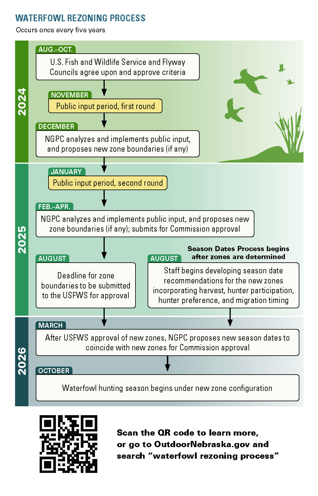
Every five years, the USFWS allows changes to waterfowl zone boundaries. To take advantage of this, Nebraska hunters who obtained a Harvest Information Program number will receive a postcard in November directing them to the Nebraska Game and Parks website where they can offer their input on current zone boundaries.
Hunters will print a zone map, mark any changes they desire and mail the form back. “Nebraska has a history of working with duck hunters on waterfowl zone boundaries,” said John McKinney, waterfowl program manager for the Nebraska Game and Parks, “and since this opportunity only arises every five years, it is important that we hear from hunters this November.”
During this initial round of input, only written comments will be accepted. Hunters are encouraged to suggest only small changes, as larger shifts could affect a greater number of hunters who may not agree with the change and result in no change being made. A letter in support of a boundary change with multiple signatures will not be accepted.

A second round of input will be sought in January regarding any boundary changes that are being proposed. “Nebraska is an amazing state for waterfowl hunting,” said McKinney, “and we want hunters to be engaged during this process.
The boundaries approved by the Game and Parks Board of Commissioners next spring will be submitted to the USFWS for final approval. New zone boundaries will go into effect beginning in fall of 2026. Concurrently, Game and Parks will seek input and make season date recommendations based on harvest estimates, hunter participation and preference, and migration patterns and timing.
These are important steps for hunters like Mills, who has journaled for years on success rates and the migration itself.
“With waterfowl hunting being so weather dependent,” Mills said, “it’s difficult to predict what seasons should look like. Data from this survey is crucial in determining the most effective way to set zones that can increase the success for hunters.”
