
By Justin Haag
Through work and play, I have been no stranger to the Pine Ridge Trail. Portions of the route that transects the heart of public lands in the Pine Ridge escarpment between Chadron and Crawford have served me well as a way to access scenic landscapes and wildlife, or just enjoy a short hike or bike ride.
Though I had been on many parts of the trail, which measures about 40 miles, I had never connected the dots in one attempt. That changed in June 2020 when my 17-year-old son, Sawyer, and I decided to backpack the entire trail in a weekend. It is something I had been considering for years and, with COVID-19 restrictions in full swing, it seemed to be the perfect time for such an adventure. To boot, it would serve as a suitable way to celebrate National Trails Day, an annual occurrence the first Saturday in June.
Even though covering the distance in three days did not sound too difficult, I knew it was important to be prepared — especially considering I had never been on an overnight backpacking trip before. I pored over websites to gain information from experienced backpackers and received guidance from U.S. Forest Service staff.
Overnight hiking has more considerations than day treks, and I was thankful backpacking has advanced. Provisions such as tents, sleeping bags, stoves and freeze-dried food have become optimized for weight and convenience. In the weeks leading up to our journey, Sawyer and I collected the necessary gear and knowledge.
While the Pine Ridge Trail may not qualify as a true “thru-hike” — serious backpackers consider those to be 300 miles or longer — it does provide a substantial challenge of three or four days. You will be hard-pressed to find another wilderness trail hiking opportunity this long in Nebraska.
Just because it is in Nebraska and not the mountains, the trail should not be mistaken as easy. After inserting the mileage, elevation gains and time into an online calculator for hiking difficulty, I found it doubled the minimum score for the “extreme” ranking.
Although an occasional ridge or canyon bottom provides level hiking, the trail does not follow any one valley or highland. Rather, it crosses a series of steep drainages through the center of the escarpment. That means many ups and downs. The elevations range from 3,700 feet near Chadron State Park to 4,590 feet just east of East Ash Creek. During the trip, we climbed 5,754 feet and descended 5,662.
Horseback is surely the least physical way to explore a trail such as this one. A mountain bike is an option, but it surely will need a lot of pushing.
The trail is not finely manicured. Most of it is unkempt single-track, with an occasional stretch of two-track. At times, users must search the landscape for the next marker post. In early June, we found areas of the trail to be choked with vegetation and ticks to be abundant, especially near creeks. An occasional cow pie and patches of poison ivy also needed to be dodged, though each seemed less frequent as we traveled west.
Because the Pine Ridge Trail intersects others throughout the Pine Ridge, you could easily stray off-course if not attentive. For most navigation, we used the lesser-detailed imagery of a GPS unit, resorting to apps such as Avenza and OnX only when we got in a jam. For most of the trip, we left our smartphones on airplane mode, using them only minimally to preserve battery.
Day One: Spotted Tail to Coffee Mill Butte
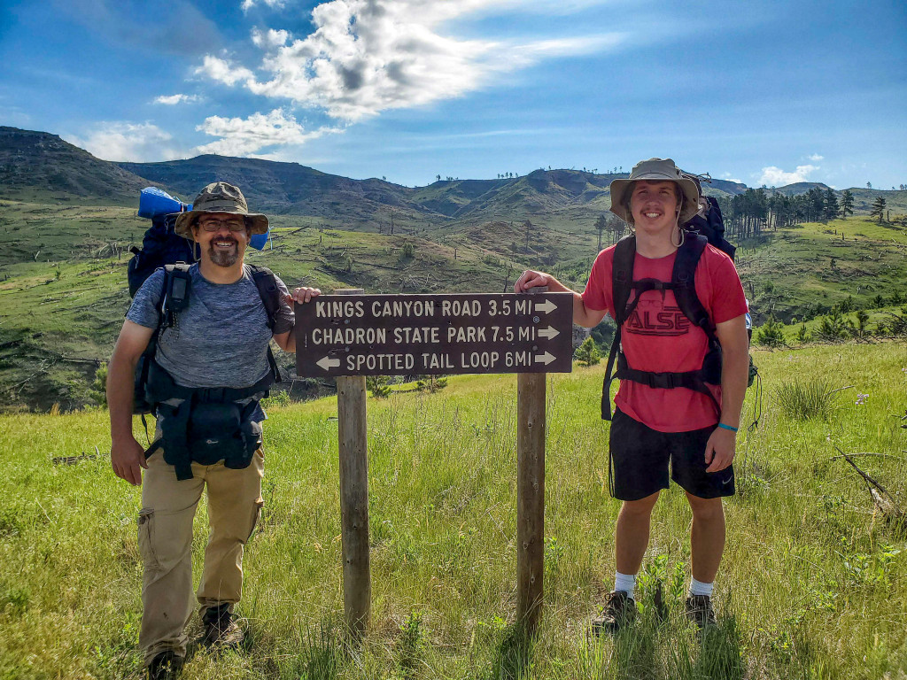
Primarily because we live in Chadron and it would be most convenient for my wife, Cricket, to leave work and drop us off at the trailhead Friday morning, we decided to hike from east to west.
With excitement for the journey ahead, we left the Spotted Tail Trailhead at about 8:30 a.m. under a mix of cotton candy clouds and surrounded by green grass accented by shell-leaf penstemon and other wildflowers. Light winds and temperatures near 70 made for a beautiful beginning.
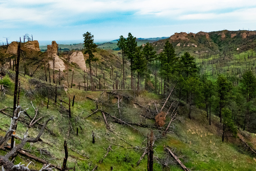
Many of the Pine Ridge’s forested areas were ravaged by wildfires in 2006 and 2012. From the get-go, this journey served as a study in how wildfire transformed the landscape. Where towering pines once stood, blackened snags, deadfall and protruding sandstone landforms accent the sweeping grasslands. The remaining stands of pines and hardwoods, still considerably present, are always welcome on the journey when they appear. Regardless, every mile is beautiful in its own way.
After the first 3½ miles, we encountered King Canyon Road — the first of four county roads that the trail intersects. We took a break and adjusted the straps on our packs. They were too loose at the top and causing the weight to tug at our shoulders like a poorly designed harness. The adjustments made remarkable difference in balance and made us wish we had done it sooner.
After another 4 miles, we crossed U.S. Highway 385 and entered Chadron State Park. The timing was right to meet Cricket and our daughter, Kiera, for lunch under the Lagoon Shelter. The park is certainly the most comfortable attraction along the route, and trail users should plan to spend some time there.
Only the park’s horses are allowed in the park, so with horseback riders in consideration the official trail courses to the Outrider Trailhead. It is about one-third of a mile north of the park along the highway, and has corrals and other amenities for the equestrian crowd. From there the trail circles Chadron State Park’s southern border. Hikers and cyclers, however, have the option to enter the park’s extensive trail system and hook up with the Pine Ridge Trail from a number of outlets — certainly convenient, but potentially confusing. We hopped on the Norwesca Trail behind the park’s duplex cabins and followed it to an intersection with the Pine Ridge Trail at the park’s southwest corner.
This is when the hike started getting tough for this short-legged, middle-aged man. With the afternoon heat and the stifling air among the trees, the steep climb from the park to the ridge above was brutal. Once at the top, a windmill with a full stock tank was a welcome sight. We used a filtering system to drink the cold water coming from the pipe and dunked our heads in the tank. It was a glorious pit stop.
Water is one of the most important considerations for a trip such as this. Carry too much and you become weighed down. Carry too little and you become dehydrated. It was especially important on this day, as a fellow hiker had told us no other water sources exist between this point and Deadhorse Road.
From the windmill, we headed south over Chadron Creek Ranch Wildlife Management Area. It is a beautiful piece of property I love to explore, but the trail passes along the fence at its lesser scenic western border. We welcomed the level terrain, however, and the U.S. Forest Service recently had been in with chainsaws to clear burned pines fallen on the trail — a task that has kept workers busy since the 2012 fire. We will be eternally grateful for their work. With 40 pounds strapped to your back, the last thing you want to do is step over a bunch of logs.
After leaving Chadron Creek Ranch and re-entering Forest Service property, the trail descends to Deadhorse Road. I had driven this county road countless times, and yet this 2-plus mile section seemed so much longer on foot. Each step became a challenge, but we knew we had to keep moving to make camp before dark. Sweating profusely, we were wishing we had been a little more careful about rationing that water.
Two men working at the sawmill along the road gave as a holler as we passed.
“On a hike, eh?”
“Yep. Started at Spotted Tail this morning,” I said.
“You’ve been at it a while, then. Looks like you might get a little wet,” one said with a grin.
We raised our weary eyes, which had been fixed on the road, to see the dark clouds creeping over the canyon. We felt a new sense of urgency.
Like children in the back seat during a long road trip, we often repeated a question. Instead of saying “Are we there, yet?” the question “Where is the butte?” became our refrain.
After what seemed like an eternity, we saw magnificent Coffee Mill Butte against the sky above, and at 7:08 p.m. reached the trailhead where we planned to camp.
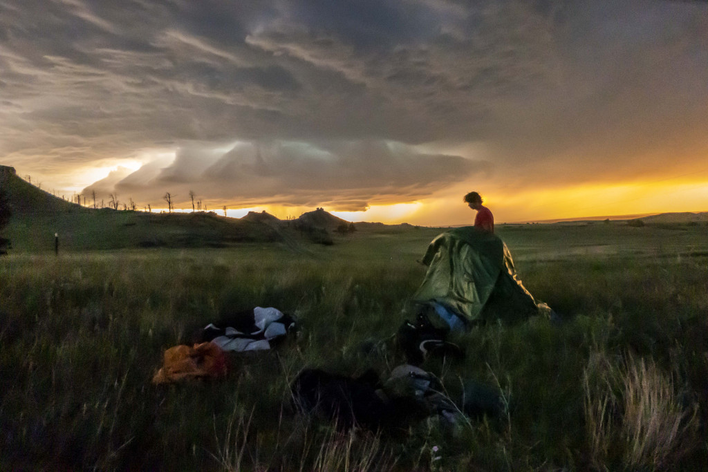
We sat down for a break, but with the encroaching storm clouds, we knew we could not rest long before finding water to drink.
Looking back, we should have had a better plan. A topographical map showed a spring nearby, but we found none in that spot. It was either battle the brush to get to a marshy area below our campsite, which may or may not have suitable water, or head back up the road to filter some beneath the last creek bridge.
We did neither. With the wind picking up and lightning becoming more frequent, we cowered to human comforts and headed down the driveway of friends who lived nearby. We saw some amazing views over the weekend, but their garden hose may have been the most beautiful sight of the entire journey.
With our bellies and containers finally full of water, we hurried back to camp to set up our tents and crawled inside with the storm fast approaching. Despite all the wind, rain, lightning and thunder, it felt so relaxing to be off our feet. The wind continued all night and made for a rough sleep.
When recounting the fatigue, thirst and weather of the first night, Sawyer would later tell me, “That was one of the hardest things I’ve done. I thought we were going to die.”
We have since considered petitioning the county for changing the name of Deadhorse Road to Deadhiker Road.
Day one, 47,939 steps and 17.2 miles down.
Day Two: Coffee Mill Trailhead to East Ash Creek
At sunrise, we fired up the mini stove to heat water for freeze-dried meals and, of paramount importance to this old hiker, Folger’s instant coffee.
With camp packed up, we hit the trail at 8:30 a.m. for what was surely the most scenic day of the journey. On a related note, it also had some of the most sizable climbs and descents.
The day began with an immediate 350-foot ascent to the Coffee Mill Overlook, the first of numerous compelling vantages of the day.
This stretch of the journey would provide plenty of drinking water, as we encountered both windmills and coldwater streams. The trail passes over Turkey Track Spring, Trunk Butte Creek, Indian Creek and Cunningham Creek. Each offers peaceful places to take a break and enjoy the soul-soothing sounds only a babbling brook can provide.
The most memorable climb was the one that took us from Trunk Butte Creek up about 400 feet to the base of Turtle Rock — a landform that you will not find on most maps, but is so distinctly chelonian in appearance that it should be noted.
At 5:52 p.m., we arrived at our campsite at the trailhead on East Ash Creek. Just as the night before, we did not have much of a rest before storm clouds cleared the canyon walls.
We raced to set up camp to beat the storm. While staking my tent, it blew from my hands and wound up tangled in a barbed-wire fence nearby. After careful removal — and a few swear words — I was more successful on the second attempt. Sawyer, in contrast, stayed calm and methodical the entire time.
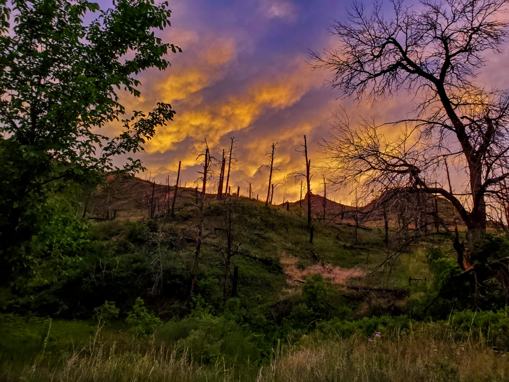
For the second night, we got inside just before the downpour started. Thankfully, the storm soon yielded to a beautiful sunset with a chorus of birds echoing in the calm of the canyon.
Day two, and another 34,757 steps and 12.9 miles down.
Day Three: East Ash Creek to West Ash Creek
Despite my sore legs and blistered feet, Sunday morning’s hike was enjoyable, and we seemed to have a spring in our step knowing the end was near. A better night of sleep also helped.
The long, steady climb from East Ash Creek offered attractive views. Once atop the ridge, only one sizable drainage, which dips about 300 feet, stands between trail users and the descent to West Ash Creek.
As we approached that final descent, we stopped to snap a final trail marker photo and enjoy the view. After reaching West Ash Road, we walked north one-third of a mile to the creek-side picnic area maintained by the Forest Service. Time of arrival: 12:19 p.m.
Day three and another 15,121 steps and 4.9 miles down. The GPS unit showed we had covered 37.19 miles in 15 hours, 58 minutes and 56 seconds. We’d been on the trail for two days, three hours and 53 minutes.
Final Thoughts
With some of Nebraska’s most captivating scenery behind us — not to mention ups, downs, ticks, thunderstorms, cow pies and patches of poison ivy — we stretched out on a picnic table with West Ash Creek playing its soothing sounds nearby.
Cricket and Kiera’s arrival with a bucket of fried chicken and cold sodas was certainly a joyous occasion, as was an obligatory stop in Crawford for ice cream.
While traveling U.S. Highway 20 from Crawford to Chadron in the air-conditioned comforts of the truck, I marveled while looking south over the open plain. The familiar sight of the Pine Ridge in the distance, and the land we had covered, had taken on new meaning to Sawyer and me.
The journey certainly helped us meet our goal of “social distancing.” Even though we saw some horse prints, footprints and bicycle tracks along the way, counting the number of other trail users met during the trip was easy: zero.
With a total of 97,817 steps, the trail also served well for my fitness. When I returned home, the scale showed I had lost eight pounds. Being our first time, we probably carried too much stuff. I have since read that backpackers should not carry more than 20 percent of their body weight. An old dog like me might want to get that percentage down to 15.
That weekend not only coincided with National Trails Day, but also with D-Day — the World War II battle of 1944 in which the Allies stormed the beaches of France under heavy gunfire and headed inland on foot to fight the Nazis through dense marshes and hedgerows. Our adventure gave us an opportunity to contemplate the military members who have hiked with heavy gear with the fear of being shot, to give us the freedoms to enjoy a recreational backpacking adventure such as this.
Would I backpack the Pine Ridge Trail again? Definitely. Would I do it all in one chunk? Maybe, but I would surely allow more time to do so. With our Sunday deadline, it seemed we were too busy hiking toward our destination to stop and smell all of those pretty flowers. Short overnighters to places such as Turkey Track Spring and Cunningham Creek seem most attractive now.
Regardless, Sawyer and I considered it an outstanding adventure and a way to gain a deeper appreciation of, and respect for, our home turf. Moreover, we contracted no viruses while doing so.